


Halifax Crash


Handley Page Halifax G-AIHU
Crashed into Cwm Mountain at about 1636 hrs GMT, Friday 5
th
December 1947
The aircraft was owned by the Lancashire Aircraft Corporation, with a crew of four who did not survive the impact.
Special thanks to Alan Clark of www.peakdistrictaircrashes.co.uk for most of the information on this page

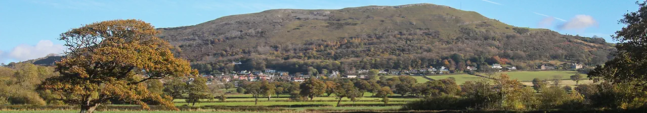
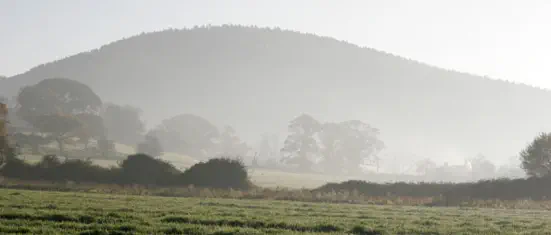
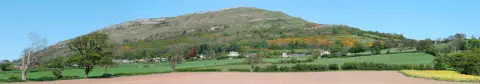
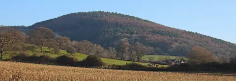
Moel Hiraddug on the left and Mynydd y Cwm (Cwm Mountain) on the right
Captain
Mr John H. Parsonage DFC
First Officer
Mr John Driver
Navigating Officer
Mr Allan Brook
Radio Officer
Mr John E. Evans
The crash site was given as:
Summit of Cwm Mountain, St Asaph, North Wales. 21.75 miles west of
Speke Airport.
A marker on the map shows the rough position.
On the morning of December 5
th
the aircraft flew from Bovingdon to Lille, France, where it was loaded with 96 bales of fabric with a total weight of 6380 kg (14036 lbs).
The aircraft was constructed by Handley Page Ltd and its flight tests were completed in March 1945.
It was purchased by the Lancashire Aircraft Corporation from the Ministry of Supply and went back to Handley Page for a Certificate of Airworthiness overhaul. The
certificate was issued on 25th September 1947. On that date the aircraft’s total flying time was 12 hours 40 minutes. At the time of the crash the flying time was approx
215 hours.
Three of the Hercules engines were made by the Bristol Aeroplane Company and had each completed 215 hours since new. The port inner engine was built by the Rover
Company and had done 219 hours.

The actual aircraft.
Image supplied by the A. J. Jackson collection at Brooklands Museum www.ajjcollection.co.uk
At Lille a flight plan was submitted to Control indicating a direct flight to Speke in I.F.R (instrument Flight Rules) conditions in an estimated time of 1.5
hours. Before departure at 1438 hrs GMT the pilot was briefed about the poor weather over England.
The aircraft established W/T communication with Uxbridge Area Control during the early part of the flight and three times reported its position. The last
plot showed that 57 minutes after take-off the aircraft was 31 miles off its course.
The weather at Speke Airport at 1625 hours was Fog. Visibility 900 yards. Clouds 4/10 at 1200 feet, 9/10 at 2500 feet. Wind NE by E 13 mph. QFE 974mb,
QFF 976mb.
The local weather at the time of the accident (from local witnesses) was Fog, Continuous slight drizzle, top of the mountain obscured by clouds.

Cwm Mountain from Moel Hiraddug
Accident Inspection
An inspection at the scene of the accident showed that the aircraft was travelling at high speed when it struck a group of fir trees growing approximately
10 ft below the summit of the thickly wooded Cwm Mountain, the height of which is 998 feet above sea level.
Nine fir trees were snapped off 30 ft above the ground by the first impact.
The wreckage trail spread down the eastern slope of the hill in a direction of 85 degrees M and extended for 400 yards, through bushes and
undergrowth.
The trail revealed continuous disintegration of wing, fuselage and undercarriage structure; the engines were torn from their mountings and small fires
had been centred around burst fuel tanks.
The trail culminated in the main wreckage where the rear portion of the fuselage was in an inverted position.
Nearby lay the twisted debris of the pilot’s compartment, the port wing and undercarriage and the burnt out remains of the starboard wing.
A technical examination showed that the undercarriage and flaps were retracted at the moment of impact and that the engines were running under
power.
The pilot’s altimeter was not recovered.
I took these pictures of the
memorial on Cwm Mountain on
19th March 2014
SJ 07269 76725
Robert Jones took this picture of the memorial in October 2020
and I enlarged the plaque
The Crew - extracts from the accident report
The Captain
Mr John H. Parsonage joined the R.A.F. On 12
th
April 1938 and was awarded his pilot’s flying badge on 31
st
July 1942. His R.A.F. Duties included operational flights
in Halifax aircraft.
He was released from the R.A.F. on 26
th
January 1947 upon the completion of his service.
He passed a general flying test on 2
nd
July 1947 and was granted a Class ‘B’ pilot’s license on 3
rd
September 1947 and was subsequently endorsed for Haltons. He
had completed approximately 2,000 flying hours, of which 1,025 hours were in Halifaxes. His night flying hours totalled 580.
According to his service logbook he had carried out 56 hours of instrument flying of which 20 hours were as 1
st
pilot. Link trainer instruction was stated to be 49
hours.
The records of the operating company show that this officer had operated 120 hours as 1
st
pilot since engagement.
First Officer
Mr John Driver applied for his ‘B’ License on 30
th
September 1946 and then stated that he had completed 552 hours flying as 1
st
pilot during his service in the
R.A.F.V.R. His ‘B’ license, No. 24161 was granted on 11
th
January 1947 and was endorsed for Haltons. It was valid at the time of the accident.
The operating company state that he had completed 175 hours flying in this type.
On this flight he also undertook the duties of Flight Engineer.
Navigating Officer
Mr Allan Brook stated that his navigational experience in the R.A.F. Amounted to 843 hours by day and 263 by night, of which 750 hours were on trans-atlantic
ferry duty using astro and radio aids only.
He was issued with a modified 1
st
Class Navigator’s license No. 2319 on 28
th
July 1947.
Radio Officer
Mr John E. Evans applied for a Radiotelegraphy License on 26
th
February 1947. He then stated that he had carried out 5.5 years service in the R.A.F. and
Transport Command and had 1650 hours flying experience. A provisional Certificate of Proficiency No.1386 was granted on 17
th
April 1947 after an examination.
According to the operating company Mr Evans had flown 181 hours for them as Radio Officer.

Notes on the Flight Details
W/T means Wireless Telegraphy and was communication by morse code, using a morse key.
R/T is Radio Telephony which is voice communication.
The “Q codes” quoted below were/are are series of three-letter codes, starting with ‘Q’ which were devised to save time when using morse code. Each
represented a statement or question and dozens of these had to be learned. When I trained as a Marine Radio Officer in the 1960s I had to learn dozens of Q
codes for marine use; many of which were also used in aviation. - Pete Robinson
Flight Details taken from the Accident Report.
G-AIHU departed Lille at 1438 hours gmt under IFR conditions. (Instrument Flight Rules - because of poor visibility en route)
W/T communication with Uxbridge Area Control was established at 1506 hrs. The aircraft reported that at 1456 hrs its position was 51.03N 02.23E, height 2,500
ft.
At 1518 hrs the aircraft reported its position for 1515 hrs as “Over East Coast, altitude 2,500 ft”.
At 1536 hrs Uxbridge Control requested the aircraft to give its position, to which the reply came “my position was 52.30N, 00.10E at 1535 hrs. Shall I send on
Manchester (Ringway) Area Control?”
Uxbridge replied “Establish communication with Manchester (Ringway)”.
The Northern Area Control Logs showed that communication with G-AIHU was not established. Enquiries revealed, however, that G-AIHU’s call sign was heard
and noted at 1559 hrs, whilst a transmission to another aircraft was in operation.
Upon completion of that signal the Northern Area operator called G-AIHU at 1602 hrs and again at 1604 hrs but failed to make contact. Neither the Control
Officer nor the Control Clerk was informed of this occurrence.
The next message from the aircraft was received at 1605 hrs by approach control, Speke Airport, requesting a QTE (A true bearing from Speke).
This was taken and passed back to the aircraft as 134 degrees. The aircraft acknowledged this signal and replied “QAD Lille 1438 QAB GJEA QAH 2500 ft.”
(Departed Lille 1438 hrs, my destination is Speke, my altitude is 2500 ft).
On acknowledgement Speke added a request for QAA (Estimated time of arrival) to which the aircraft replied “wait”.
At 1610 hrs the aircraft came back with QAA GJEA 1620z (my ETA at Speke is 1620 hrs gmt).
At 1613 hrs Speke called the aircraft and said “QGL QHZ QBV 2000 QGP2 QSY R/T” (you may enter the zone, circle the aerodrome, report reaching 2000 ft,
your turn for landing is number 2, send on R/T).
“Send on R/T” indicated that the Approach Controller handed the aircraft to the Aerodrome Controller with whom R/T (voice) communication should be
established. In the normal course of events the Approach Controller would have received no further messages from the aircraft. R/T communication with the
Aerodrome Controller, however, was not established and the wireless operator of Approach Control attempted to re-open communication at 1626 hrs and 1627
hrs, but without success.
After working another aircraft the operator made contact with G-AIHU at 1628 hrs when the aircraft passed the following plain language message on W/T -
“Unable to raise 6440 - landing instructions?”
This indicated to the approach controller that R/T communication with Aerodrome Control could not be effected and that the aircraft required landing instructions
by W/T (morse code).
At 1632 hrs the aircraft requested a QDM (Magnetic course to steer, with zero wind, to reach Speke). This was passed as 090 degrees and was immediately
followed by the landing instructions signal “QHG QHE2 QGP1 QFM 1000 ft”. (You are cleared to enter the traffic circuit, inform me when you are on the down-
wind leg, your turn for landing is No.1, maintain (or fly at) an altitude of 1000 ft.
Receipt of this message was acknowledged.
At 1635 hrs the Approach Controller originated the signal QTH? QAA? (What is your position? What is your ETA?). An acknowledgement of this message was the
aircraft’s last signal.
From the evidence of witnesses it has been established that at approximately 1615 hrs G-AIHU was flying at 400 to 450 ft over Hooton Park aerodrome and
heading towards West Kirby, on the N.E. Coast of the Wirral Peninsula.
It is believed that the aircraft flew out to sea, as at 1630 hrs the attention of a policeman at Prestatyn was attracted by a four engined aircraft flying low in a
south westerly direction. Another witness stated that he was just south of Rhyl when he sighted a four engined aircraft flying so low that he flung himself to the
ground as he thought the aircraft would hit some nearby trees but that it flew on in a south westerly direction.
An army officer at Kinmel Park Camp, Bodelwyddan, 5 miles west of Cwm Mountain, stated that at about 1630 hrs he heard a low flying aircraft, obscured by
mist, flying in an easterly direction.
At St Asaph, 2.5 miles from the scene of the accident, another witness stated that he saw G-AIHU flying low with its undercarriage down and engines emitting
an irregular running note, heading towards Cwm.
The evidence of witnesses situated nearer to the scene of the accident showed that the aircraft continued in straight flight until striking the cloud obscured hill.
All photographs on this page are Copyright © Peter J Robinson 2015
except the aircraft photo which is Copyright © the A.J. Jackson Collection 2015, the crash site photo and the photo by Robert Jones
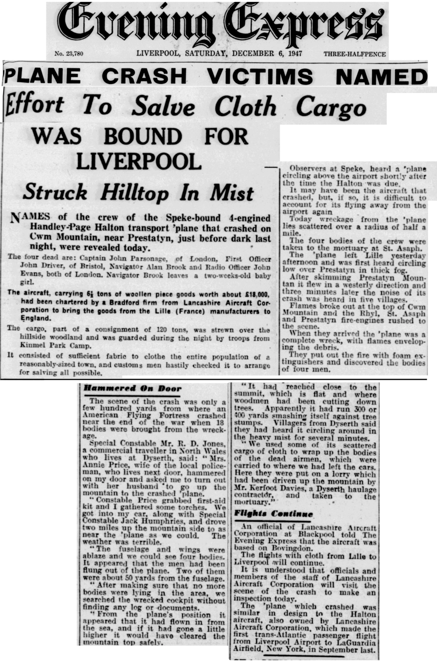
Jean Kerfoot Ashton sparked my interest when she told be about this incident. She was 10 years old at the time of the crash. Her father, William Kerfoot
Davies was an agricultural and haulage contractor and had a wagon with a canvas canopy over the back which was fitted with seats and a light to carry
men to work. They lived on Thomas Avenue, Dyserth. Kerfoot Davies later set up Voel Coaches.
Her younger brother, Stuart, was with his friend, Elwyn Jones at the playground when they heard the aircraft crash into the hillside and rushed home to tell
his mother - who at first didn’t believe them.
The local policeman, PC Price, lived next door to the family and asked Kerfoot if he would take his wagon onto Cwm Mountain to the crash site. He drove
there with the policeman and they brought the bodies of the 4 aircrew back to the village. As there were trees on the mountain she thinks that they got the
wagon as far as the cottage called Aelwyd Ucha and brought the bodies to that point. She recalls that the collection of the bodies was not discussed.
The aircraft was carrying bales of cloth that were strewn over the mountain and Jean remembers that everyone in the village, including PC Price, had
something made from it. She had a gymslip, her brothers Stuart and Melvyn maybe had shorts and most men had a suit, including Price the Policeman.
There was a lady who was a tailor living next door and she made up the clothing.
As children she remembers going onto the mountain and collecting parts of the aircraft, in particular some plastic, that if you burnt a hole in it it could
become a ring.
Other people have told me they remember finding plastic that they could burn holes in with a hot poker and make rings.

The crash site, the following day


Handley Page Halifax G-AIHU
Crashed into Cwm Mountain at about 1636 hrs GMT, Friday
5
th
December 1947
The aircraft was owned by the Lancashire Aircraft
Corporation, with a crew of four who did not survive the
impact.
Special thanks to Alan Clark of
www.peakdistrictaircrashes.co.uk for most of the information
on this page
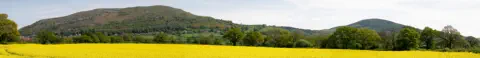
Moel Hiraddug on the left and Mynydd y Cwm
(Cwm Mountain) on the right
Captain
Mr John H. Parsonage DFC
First Officer
Mr John Driver
Navigating Officer
Mr Allan Brook
Radio Officer
Mr John E. Evans
The crash site was given as:
Summit of Cwm Mountain, St Asaph, North Wales. 21.75
miles west of Speke Airport.
A marker on the map shows the rough position.

On the morning of December 5
th
the aircraft flew from
Bovingdon to Lille, France, where it was loaded with 96
bales of fabric with a total weight of 6380 kg (14036 lbs).
The aircraft was constructed by Handley Page Ltd and its
flight tests were completed in March 1945.
It was purchased by the Lancashire Aircraft Corporation
from the Ministry of Supply and went back to Handley Page
for a Certificate of Airworthiness overhaul. The certificate
was issued on 25th September 1947. On that date the
aircraft’s total flying time was 12 hours 40 minutes. At the
time of the crash the flying time was approx 215 hours.
Three of the Hercules engines were made by the Bristol
Aeroplane Company and had each completed 215 hours
since new. The port inner engine was built by the Rover
Company and had done 219 hours.
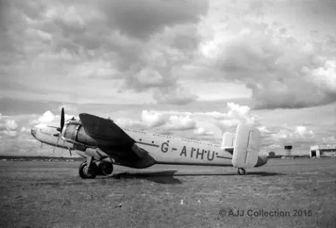
The actual aircraft.
Image supplied by the A. J. Jackson collection at
Brooklands Museum www.ajjcollection.co.uk
At Lille a flight plan was submitted to Control indicating a
direct flight to Speke in I.F.R (instrument Flight Rules)
conditions in an estimated time of 1.5 hours. Before
departure at 1438 hrs GMT the pilot was briefed about the
poor weather over England.
The aircraft established W/T communication with Uxbridge
Area Control during the early part of the flight and three
times reported its position. The last plot showed that 57
minutes after take-off the aircraft was 31 miles off its
course.
The weather at Speke Airport at 1625 hours was Fog.
Visibility 900 yards. Clouds 4/10 at 1200 feet, 9/10 at 2500
feet. Wind NE by E 13 mph. QFE 974mb, QFF 976mb.
The local weather at the time of the accident (from local
witnesses) was Fog, Continuous slight drizzle, top of the
mountain obscured by clouds.
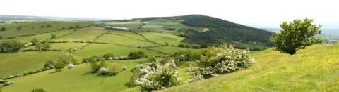
Cwm Mountain from Moel Hiraddug
Accident Inspection
An inspection at the scene of the accident showed that the
aircraft was travelling at high speed when it struck a group
of fir trees growing approximately 10 ft below the summit of
the thickly wooded Cwm Mountain, the height of which is
998 feet above sea level.
Nine fir trees were snapped off 30 ft above the ground by the
first impact.
The wreckage trail spread down the eastern slope of the hill
in a direction of 85 degrees M and extended for 400 yards,
through bushes and undergrowth.
The trail revealed continuous disintegration of wing, fuselage
and undercarriage structure; the engines were torn from
their mountings and small fires had been centred around
burst fuel tanks.
The trail culminated in the main wreckage where the rear
portion of the fuselage was in an inverted position.
Nearby lay the twisted debris of the pilot’s compartment, the
port wing and undercarriage and the burnt out remains of
the starboard wing.
A technical examination showed that the undercarriage and
flaps were retracted at the moment of impact and that the
engines were running under power.
The pilot’s altimeter was not recovered.
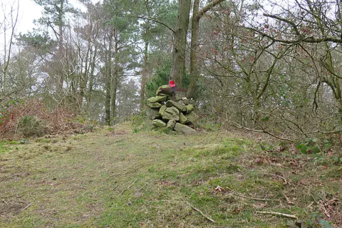
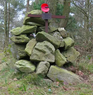
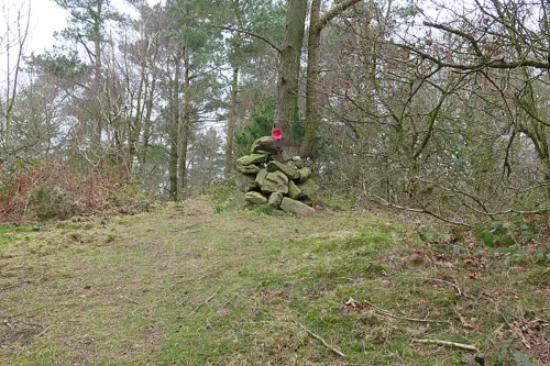
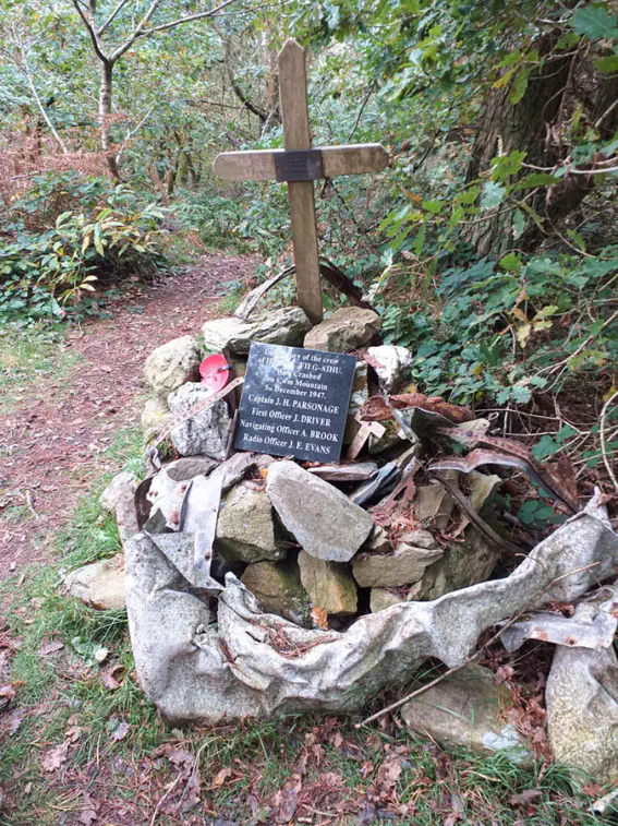
I took these
pictures of the
memorial on Cwm
Mountain on 19th
March 2014
SJ 07269 76725
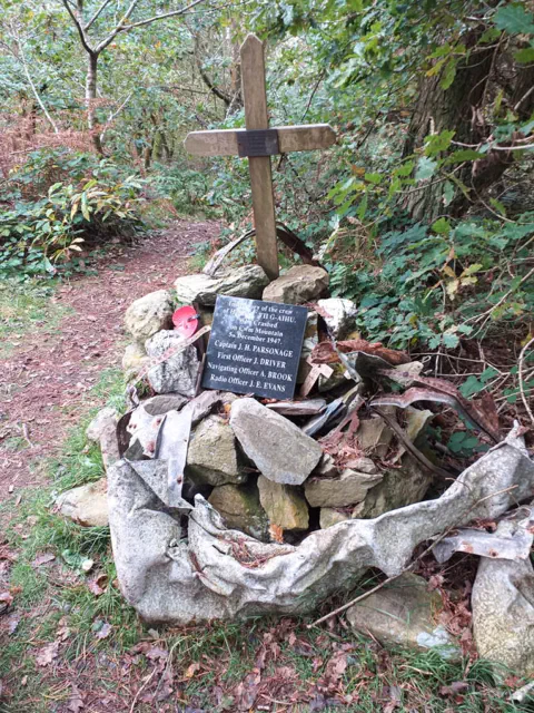
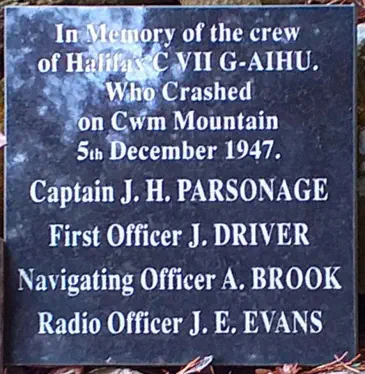
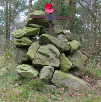
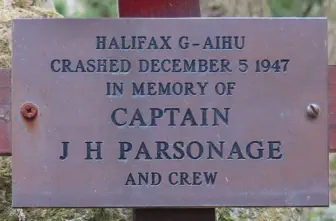
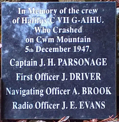
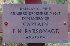
Robert Jones took this picture of the memorial in
October 2020 and I enlarged the plaque
The Crew - extracts from the accident report
The Captain
Mr John H. Parsonage joined the R.A.F. On 12
th
April 1938
and was awarded his pilot’s flying badge on 31
st
July 1942.
His R.A.F. Duties included operational flights in Halifax
aircraft.
He was released from the R.A.F. on 26
th
January 1947 upon
the completion of his service.
He passed a general flying test on 2
nd
July 1947 and was
granted a Class ‘B’ pilot’s license on 3
rd
September 1947 and
was subsequently endorsed for Haltons. He had completed
approximately 2,000 flying hours, of which 1,025 hours were
in Halifaxes. His night flying hours totalled 580.
According to his service logbook he had carried out 56 hours
of instrument flying of which 20 hours were as 1
st
pilot. Link
trainer instruction was stated to be 49 hours.
The records of the operating company show that this officer
had operated 120 hours as 1
st
pilot since engagement.
First Officer
Mr John Driver applied for his ‘B’ License on 30
th
September
1946 and then stated that he had completed 552 hours
flying as 1
st
pilot during his service in the R.A.F.V.R. His ‘B’
license, No. 24161 was granted on 11
th
January 1947 and
was endorsed for Haltons. It was valid at the time of the
accident.
The operating company state that he had completed 175
hours flying in this type.
On this flight he also undertook the duties of Flight Engineer.
Navigating Officer
Mr Allan Brook stated that his navigational experience in the
R.A.F. Amounted to 843 hours by day and 263 by night, of
which 750 hours were on trans-atlantic ferry duty using
astro and radio aids only.
He was issued with a modified 1
st
Class Navigator’s license
No. 2319 on 28
th
July 1947.
Radio Officer
Mr John E. Evans applied for a Radiotelegraphy License on
26
th
February 1947. He then stated that he had carried out
5.5 years service in the R.A.F. and Transport Command and
had 1650 hours flying experience. A provisional Certificate of
Proficiency No.1386 was granted on 17
th
April 1947 after an
examination. According to the operating company Mr Evans
had flown 181 hours for them as Radio Officer.
Notes on the Flight Details
W/T means Wireless Telegraphy and was communication by
morse code, using a morse key.
R/T is Radio Telephony which is voice communication.
The “Q codes” quoted below were/are are series of three-
letter codes, starting with ‘Q’ which were devised to save
time when using morse code. Each represented a statement
or question and dozens of these had to be learned. When I
trained as a Marine Radio Officer in the 1960s I had to learn
dozens of Q codes for marine use; many of which were also
used in aviation. - Pete Robinson
Flight Details taken from the Accident Report.
G-AIHU departed Lille at 1438 hours gmt under IFR
conditions. (Instrument Flight Rules - because of poor
visibility en route)
W/T communication with Uxbridge Area Control was
established at 1506 hrs. The aircraft reported that at 1456
hrs its position was 51.03N 02.23E, height 2,500 ft.
At 1518 hrs the aircraft reported its position for 1515 hrs as
“Over East Coast, altitude 2,500 ft”.
At 1536 hrs Uxbridge Control requested the aircraft to give
its position, to which the reply came “my position was
52.30N, 00.10E at 1535 hrs. Shall I send on Manchester
(Ringway) Area Control?”
Uxbridge replied “Establish communication with Manchester
(Ringway)”.
The Northern Area Control Logs showed that communication
with G-AIHU was not established. Enquiries revealed,
however, that G-AIHU’s call sign was heard and noted at
1559 hrs, whilst a transmission to another aircraft was in
operation.
Upon completion of that signal the Northern Area operator
called G-AIHU at 1602 hrs and again at 1604 hrs but failed
to make contact. Neither the Control Officer nor the Control
Clerk was informed of this occurrence.
The next message from the aircraft was received at 1605 hrs
by approach control, Speke Airport, requesting a QTE (A true
bearing from Speke).
This was taken and passed back to the aircraft as 134
degrees. The aircraft acknowledged this signal and replied
“QAD Lille 1438 QAB GJEA QAH 2500 ft.” (Departed Lille
1438 hrs, my destination is Speke, my altitude is 2500 ft).
On acknowledgement Speke added a request for QAA
(Estimated time of arrival) to which the aircraft replied
“wait”.
At 1610 hrs the aircraft came back with QAA GJEA 1620z
(my ETA at Speke is 1620 hrs gmt).
At 1613 hrs Speke called the aircraft and said “QGL QHZ
QBV 2000 QGP2 QSY R/T” (you may enter the zone, circle
the aerodrome, report reaching 2000 ft, your turn for
landing is number 2, send on R/T).
“Send on R/T” indicated that the Approach Controller handed
the aircraft to the Aerodrome Controller with whom R/T
(voice) communication should be established. In the normal
course of events the Approach Controller would have
received no further messages from the aircraft. R/T
communication with the Aerodrome Controller, however, was
not established and the wireless operator of Approach
Control attempted to re-open communication at 1626 hrs
and 1627 hrs, but without success.
After working another aircraft the operator made contact
with G-AIHU at 1628 hrs when the aircraft passed the
following plain language message on W/T - “Unable to raise
6440 - landing instructions?”
This indicated to the approach controller that R/T
communication with Aerodrome Control could not be effected
and that the aircraft required landing instructions by W/T
(morse code).
At 1632 hrs the aircraft requested a QDM (Magnetic course
to steer, with zero wind, to reach Speke). This was passed as
090 degrees and was immediately followed by the landing
instructions signal “QHG QHE2 QGP1 QFM 1000 ft”. (You are
cleared to enter the traffic circuit, inform me when you are
on the down-wind leg, your turn for landing is No.1,
maintain (or fly at) an altitude of 1000 ft.
Receipt of this message was acknowledged.
At 1635 hrs the Approach Controller originated the signal
QTH? QAA? (What is your position? What is your ETA?). An
acknowledgement of this message was the aircraft’s last
signal.
From the evidence of witnesses it has been established that
at approximately 1615 hrs G-AIHU was flying at 400 to 450
ft over Hooton Park aerodrome and heading towards West
Kirby, on the N.E. Coast of the Wirral Peninsula.
It is believed that the aircraft flew out to sea, as at 1630 hrs
the attention of a policeman at Prestatyn was attracted by a
four engined aircraft flying low in a south westerly direction.
Another witness stated that he was just south of Rhyl when
he sighted a four engined aircraft flying so low that he flung
himself to the ground as he thought the aircraft would hit
some nearby trees but that it flew on in a south westerly
direction.
An army officer at Kinmel Park Camp, Bodelwyddan, 5 miles
west of Cwm Mountain, stated that at about 1630 hrs he
heard a low flying aircraft, obscured by mist, flying in an
easterly direction.
At St Asaph, 2.5 miles from the scene of the accident,
another witness stated that he saw G-AIHU flying low with
its undercarriage down and engines emitting an irregular
running note, heading towards Cwm.
The evidence of witnesses situated nearer to the scene of
the accident showed that the aircraft continued in straight
flight until striking the cloud obscured hill.
All photographs on this page are Copyright
© Peter J Robinson 2015
except the aircraft photo which is
Copyright © the A.J. Jackson Collection
2015, the crash site photo and the photo
by Robert Jones
Halifax Crash
Jean Kerfoot Ashton sparked my interest when she told be
about this incident. She was 10 years old at the time of the
crash. Her father, William Kerfoot Davies was an
agricultural and haulage contractor and had a wagon with
a canvas canopy over the back which was fitted with seats
and a light to carry men to work. They lived on Thomas
Avenue, Dyserth. Kerfoot Davies later set up Voel Coaches.
Her younger brother, Stuart, was with his friend, Elwyn
Jones at the playground when they heard the aircraft crash
into the hillside and rushed home to tell his mother - who
at first didn’t believe them.
The local policeman, PC Price, lived next door to the family
and asked Kerfoot if he would take his wagon onto Cwm
Mountain to the crash site. He drove there with the
policeman and they brought the bodies of the 4 aircrew
back to the village. As there were trees on the mountain
she thinks that they got the wagon as far as the cottage
called Aelwyd Ucha and brought the bodies to that point.
She recalls that the collection of the bodies was not
discussed.
The aircraft was carrying bales of cloth that were strewn
over the mountain and Jean remembers that everyone in
the village, including PC Price, had something made from
it. She had a gymslip, her brothers Stuart and Melvyn
maybe had shorts and most men had a suit, including Price
the Policeman. There was a lady who was a tailor living
next door and she made up the clothing.
As children she remembers going onto the mountain and
collecting parts of the aircraft, in particular some plastic,
that if you burnt a hole in it it could become a ring.
Other people have told me they remember finding plastic
that they could burn holes in with a hot poker and make
rings.
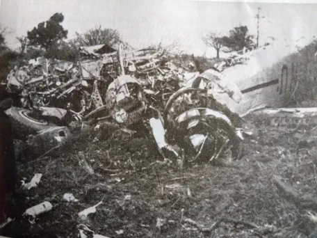
The crash site, the following day